
As drones expand into precision agriculture, infrastructure inspection, autonomous delivery, indoor automation, and industrial monitoring, they are increasingly being required to operate close to the ground.
Low-altitude flight creates a different set of sensing challenges than higher-altitude operation. At heights below approximately 10 metres, drones must respond quickly to changing terrain, confined spaces, uneven landing surfaces, obstacles, and aerodynamic instability.
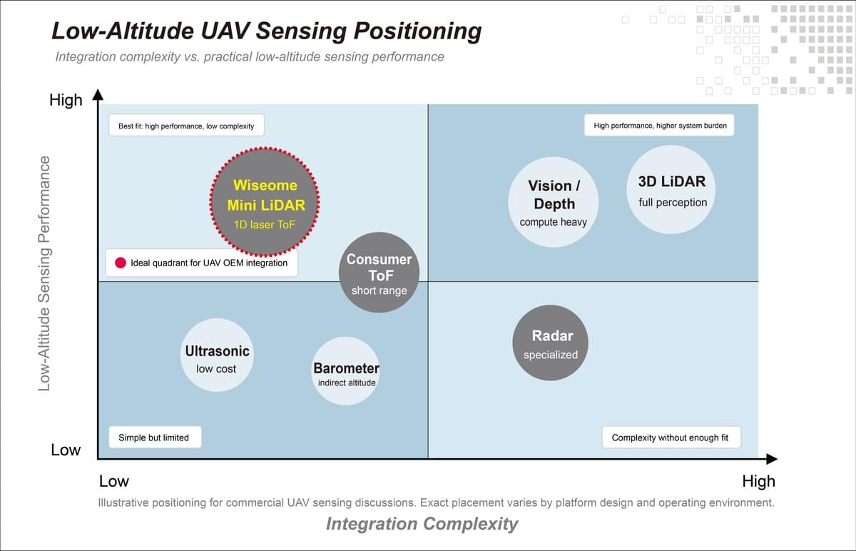
For many UAV applications, a compact 1D LiDAR sensor provides the necessary altitude and distance data without the cost, weight, or processing requirements of a full vision or 3D perception system.
Why Low-Altitude Drone Flight Is Challenging
Drones operating near the ground have less time and space to react to changes in their environment.
A small change in terrain height, an unexpected obstacle, or an inaccurate altitude reading can affect flight stability, especially during landing, hovering, and terrain-following operations.
Common low-altitude flight challenges include:
- Rapid terrain variation
- Ground-effect instability
- Tight landing tolerances
- Increased collision risk
- Limited space for corrective movement
- Irregular or reflective surfaces
- Rapid changes in altitude
These conditions are common in agricultural fields, warehouses, industrial facilities, construction sites, delivery locations, and indoor inspection environments.
A drone’s barometer, GPS, or inertial sensors may support general flight control, but they do not always provide the precise, real-time ground-distance measurements required near the surface.
Why Conventional Drone Sensors Can Fall Short
There are several technologies available for measuring altitude and detecting nearby surfaces. However, each introduces trade-offs in speed, accuracy, range, processing requirements, or environmental reliability.
Ultrasonic Sensors
Ultrasonic sensors estimate distance using sound waves.
They are relatively simple and affordable, but their performance can be affected by:
- Air movement
- Surface angle
- Soft or sound-absorbing materials
- Propeller noise
- Temperature
- Limited update speed
For fast-moving drones, inconsistent or delayed measurements may make ultrasonic sensing less suitable for precise real-time altitude control.
Vision-Based Systems
Cameras can provide detailed information about terrain, objects, and landing areas.
However, vision-based sensing typically requires substantial processing to interpret images. Performance may also be affected by:
- Low light
- Glare
- Motion blur
- Repetitive textures
- Featureless surfaces
- Changing environmental conditions
Vision systems can be valuable for navigation and object recognition, but they may introduce unnecessary complexity when the drone only needs a direct measurement of its height above the ground.
3D LiDAR Systems
Three-dimensional LiDAR generates detailed point-cloud information about the surrounding environment. This level of perception can be useful for advanced autonomous navigation, mapping, and object recognition. However, it can also introduce:
- Additional weight
- Higher power consumption
- Greater hardware cost
- More communication bandwidth
- Significant processing requirements
- More complex software integration
When the primary requirement is to measure the distance between the drone and the ground, a full 3D sensing system may provide far more data than the control system needs.
Why Laser-Based 1D LiDAR Is a Practical ToF Solution
Not all ToF implementations provide the same level of performance.
Laser-based 1D LiDAR uses dedicated optics and infrared laser emission to produce focused, high-speed distance measurements along a single axis.
For drone applications, this approach can offer:
- Longer operating range than many integrated ToF sensors
- Faster measurement rates
- Greater resistance to bright ambient light
- More reliable single-point distance data
- Lower processing requirements than camera-based depth systems
- Simpler integration than multidimensional LiDAR
A downward-facing 1D LiDAR sensor can continuously measure the distance between a drone and the surface below it.
That measurement can then be used directly by the flight controller for altitude stabilization, landing assistance, or terrain-following behaviour.
Meet the Wiseome Mini LiDAR I Series
The Wiseome Mini LiDAR I Series is a compact, laser-based 1D ToF sensor designed for real-world drone, robotics, and industrial sensing applications.
Key capabilities include:
- Up to 1,000 Hz measurement rate
- Accurate sensing from approximately 0.15 to 13 metres
- Reliable operation in ambient light up to 100,000 lux
- UART communication
- 3.3V logic compatibility
- Configurable frame rates
- Compact module design
- Lightweight embedded architecture
To learn more about integrating the Wiseome Mini LiDAR I Series into your drone or UAV platform, contact our team today!